By Wang Dinghuang
Reporter in Hong Kong Wen Wei Po
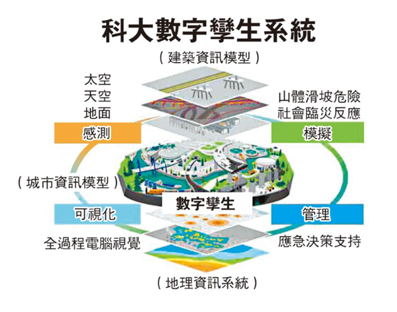
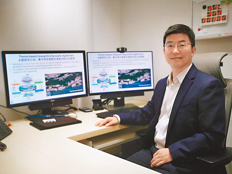
Hong Kong, characterized by dense population and limited flat land, faces a significant threat from landslides (also known as mudslides) due to its mountainous terrain. Just in the recent '9.7 torrential rain' event this year, nearly 190 landslide incidents were recorded across the city, impacting transportation and residents' daily lives in various regions. To tackle the complex challenge of landslide risk management, a team led by Prof. Zhang Limin from the Hong Kong University of Science and Technology (HKUST) secured a grant of nearly HKD 74 million from the Research Grants Council. They are now developing the first city-scale Digital Twin system capable of covering all slopes in Hong Kong. In a recent interview with Hong Kong Wen Wei Po, Prof. Zhang shared that the project integrates cutting-edge technologies, including physical modeling for simulation, smart sensing, communication networks, and the Digital Twin engine. This initiative not only pioneers real-time landslide risk assessments at a city level but also efficiently simulates societal responses such as traffic disruptions and citizen evacuations in the event of a disaster. It aims to support coordinated emergency decision-making, contributing to Hong Kong's goal of achieving 'Smart Disaster Reduction. '
Over the past 40 years, approximately 85% of fatal landslides worldwide have been triggered by rainfall and earthquakes, resulting in over 180,000 deaths. Since 1984, Hong Kong has experienced around 13,300 natural slope and 8,200 artificial slope landslides, causing significant casualties and economic losses. Prof. Zhang Limin, Director of the Department of Civil and Environmental Engineering at HKUST and Director of the Centrifuge Model Testing Facility for Geotechnical Engineering, emphasized the need for new emergency risk management theories and technologies, especially in the face of frequent extreme rainfall and intense earthquakes induced by climate change. These developments are crucial to ensuring public safety and sustainable social development in Hong Kong.
Assessing Safety Factors: Big Data Uncovering Vulnerabilities
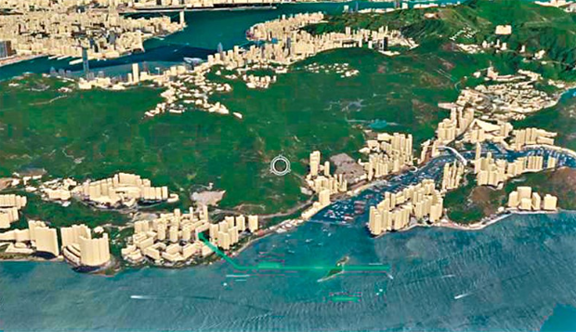
To understand when and under what conditions landslides might occur on slopes throughout Hong Kong and guide targeted reinforcement efforts more accurately, Prof. Zhang Limin's team is currently conducting the "Digital Twin-Empowered Landslide Emergency Management" project. The aim is to establish a world-leading, real-time simulation-capable, city-scale Digital Twin system covering all natural slopes, artificial slopes, buildings, and information on precipitation and earthquakes across Hong Kong. This system helps enhance the defense capabilities of existing slope safety systems, managing the risk of landslides induced by extreme rainfall and earthquakes. "It's like digital asset management; through this system, we can have a clear understanding of the actual conditions of slopes throughout the entire Hong Kong region."
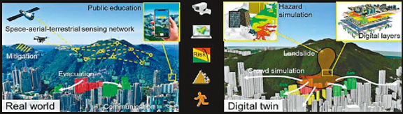
The team has collaborated with government departments, including the Geotechnical Engineering Office and the Observatory, to obtain high-precision maps of natural slopes, topography, buildings (especially houses affected by slopes), as well as precipitation and earthquake data across Hong Kong. Zhang Limin mentioned that the team also utilizes remote sensing technologies such as the "HKUST-FYBB#1" optical satellite and other synthetic aperture radar satellites to monitor in real-time the deformation and potential displacement hazards of over 60,000 artificial slopes across Hong Kong. In crucial slopes like the Po Shan Road in Mid-levels, sensors detecting slope deformation and underground water pressure have been installed, and their data is shared with the system.
"When all this data is transmitted to the Digital Twin system, we can assess the safety factor of the slope, simulate the impact area and damage extent to surrounding buildings in the event of a landslide, helping identify safety vulnerabilities and achieve slope safety monitoring and early warning," Zhang Limin explained.
Simulating Disaster Response: Strengthening On-the-Spot Adaptability
The system can also monitor and simulate emergency responses in society during landslides. "For instance, we installed fiber optic sensors on roads near Po Shan Road. When the Observatory issues an emergency signal for heavy rain, we can monitor the traffic flow and pedestrian movement, observing whether people are following traffic instructions, and such data, when integrated into the system, facilitates city and community-wide monitoring and information sharing on roads, precipitation, landslides, and communication. This assists the government in comprehensive emergency management from top to bottom."
Moreover, the Digital Twin system efficiently simulates and predicts the disaster process and societal responses. Utilizing three-dimensional computer vision technology, it vividly illustrates risk propagation and simulates the evacuation process in different disaster scenarios, providing an immersive way to educate the public on correct responses during emergencies and enhancing disaster awareness.
"This system can be expanded for use in various disaster scenarios in the future, such as earthquakes, floods, typhoons, pandemics, traffic crises, etc., becoming a universal tool for disaster and crisis management," Zhang Limin shared. The team will collaborate with international geotechnical organizations to launch projects, promoting the establishment of global standards for Digital Twin technology, aiding in the sustainable and resilient development of disaster reduction in Hong Kong and other regions.
Variable Rainfall Intensity Across Regions: Precision Needed in Landslide Warnings
Over the past 50 years, landslides have claimed the lives of over 470 people in Hong Kong. Zhang Limin highlights that Hong Kong's steep and water-rich terrain is a primary factor contributing to frequent landslides. He recommends the establishment of a more precise regional landslide warning system, offering targeted risk alerts while balancing the maintenance of everyday societal operations.
Zhang Limin points out that 60% of Hong Kong's land is natural slopes, with half of it located within country parks. Additionally, over 60% of the land in Hong Kong has a slope greater than 15 degrees, and 30% has a slope steeper than 30 degrees. Slopes composed of dry sand with an inclination exceeding 35 degrees pose a risk of collapse.
In addition to geological factors, being in a subtropical region, Hong Kong experiences abundant rainfall, particularly during seasonal heavy rains. Rainfall infiltrates the soil, saturating it, reducing soil strength, and making it prone to sliding, triggering landslides. More than half of the rainfall in Hong Kong becomes surface runoff, eroding the soil. When this runoff converges in valleys, it transforms into sediment-laden high-flow water (commonly known as "flash floods"). "Hong Kong's urban areas are close to the mountains, which increases the risk of losses from landslides," Zhang Limin notes.
Regarding the current approach to landslide warnings, Zhang Limin proposes recommendations. He suggests that, under certain rainfall intensities, the government evaluates the relationship between landslide occurrence frequency and rainfall intensity. If the assessment reveals that more than 15 artificial slopes are likely to experience landslides during a torrential rain across Hong Kong, a landslide warning signal is issued, leading to traffic control measures.
"The challenge lies in the uneven distribution of rainfall intensity across regions. For instance, during the '9.7 torrential rain,' while heavy rain severely affected Hong Kong Island, the area near the airport continued normal operations. If the predicted landslides ultimately only occur in remote mountainous areas, implementing widespread traffic control measures would affect the majority of people's travel," Zhang Limin explains. Therefore, he recommends the establishment of a zonal warning system for landslides and heavy rain risks in Hong Kong, accurately assessing buildings and populations possibly affected by landslides and regions concentrated with heavy rainfall. This would enable the precise issuance of warning signals in specific zones.
Record-Breaking Heavy Rainfall Spurs Disaster Reduction Efforts – Ongoing Improvement in Slope Safety in Hong Kong
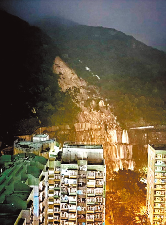
Frequent occurrences of extreme rainfall intensify the likelihood of landslides in Hong Kong. The "9.7 Torrential Rain" this year, with the severe landslide on Yiu Hing Road, serves as a notable example. In response to criticisms questioning the effectiveness of the SAR Government's disaster prevention and control efforts, Zhang Limin asserts that, compared to a similar heavy rainfall 15 years ago, the recent landslide issues triggered by this rainfall demonstrate a clear improvement in slope safety. This indicates that the management efforts on high-risk slopes have yielded positive results.
Outperforming the 2008 Rain Disaster with Zero Casualties
Zhang Limin explains that comparing the landslide data from the "9.7 Torrential Rain" this year with the last significant landslide incident in Hong Kong reveals notable progress in slope safety. He states, "On June 7, 2008, the Observatory recorded about 300 millimeters of total rainfall, resulting in approximately 360 landslide reports and two fatalities. The only road to the airport, North Lantau Highway, was closed for around 16 hours, and road access to Tai O was disrupted for about two weeks, affecting widespread areas in Hong Kong. In contrast, the recent '9.7 Torrential Rain' was even more severe, breaking records since the Observatory's establishment in 1884 with an hourly rainfall exceeding the previous records. Ultimately, there were around 190 landslide reports, with no loss of life. Some non-essential roads needed closure for one to two days, and the majority of citizens resumed normal life within one or two days."
Zhang Limin highlights the efforts of the Geotechnical Engineering Office, responsible for the systematic consolidation of government-made slopes that did not meet standards. By 2010, most high-risk government-made slopes affecting places like hospitals and schools had been consolidated, significantly reducing the overall landslide risk in Hong Kong. The "Long-term Slope Treatment Plan," initiated in the same year, expanded its scope to mitigate the risk of landslides on natural slopes and continued to consolidate other medium-risk government-made slopes. Currently, there are approximately 60,000 registered man-made slopes in Hong Kong, with about one-third being privately owned. Zhang emphasizes that, in addition to the government's ongoing efforts to maintain slope safety, private property owners must regularly maintain the slopes under their responsibility. This is particularly crucial to avoid unauthorized land leveling projects or illegal construction activities.
Targeted Slope Remediation Through Long-Term Satellite Monitoring
In addressing major geological disasters like landslides, Zhang Limin emphasizes the importance of targeted remediation for high-risk artificial or natural slopes, in addition to real-time disaster monitoring and early warnings.
He envisions that the team's ongoing development of a Digital Twin system, combined with satellite remote sensing technology, could facilitate the early identification of high-risk valleys and artificial slopes across Hong Kong. This, in turn, could support the SAR Government's departments in more effectively implementing targeted measures to safeguard urban safety.
Zhang Limin notes that while risk monitoring and warning systems play a supporting role in landslide prevention, they cannot directly reduce the occurrence of disasters. The most crucial aspect remains targeted remediation of slopes with potential hazards, including reinforcing slope surfaces. He adds, "Unless it is an extremely rare heavy rainfall event where engineering measures cannot provide protection, relying on pre-disaster warnings can help arrange evacuations in advance. However, if the region's disaster prevention engineering capabilities are weak, solely relying on pre-disaster warnings may not be sufficient to withstand disasters."
The SAR Government currently allocates 1 billion HKD annually to reinforce around 200 to 300 high-risk artificial slopes and approximately 20 to 30 natural valleys with potential landslide hazards. Zhang Limin mentions that the team's research on the Digital Twin system will utilize satellite remote sensing technology to monitor natural slopes that have experienced or might experience landslides. The system will conduct stress tests and analyze and identify high-risk valleys. The corresponding data will be shared with relevant government departments to prompt early and targeted remediation and reinforcement projects, enhancing the effectiveness of disaster reduction efforts.
(Source: Hong Kong Wen Wei Po, Page A12, Special Feature, December 23, 2023)